Key takeaways
- Why is Alaska So Big?
- Economic and Cultural Significance
- Diverse Landscapes
- How Big Is Alaska, Compared With Other Land Masses?
- Alaska Compared to Australia
- Alaska Compared to Japan
How Big is Alaska?
Alaska, the largest state in the United States, is known for its vastness and breathtaking scenery. Alaska’s dimensions are nothing short of monumental, being located in the far northwestern region of North America. Covering approximately 663,300 square miles, To provide context, if overlaid onto a map of the contiguous United States, Alaska would stretch from the West Coast to the East Coast, with plenty of room to spare. This huge landmass features a diverse collection of natural treasures, breathtaking panoramas, and untamed wildness that is unparalleled.
Why is Alaska So Big?
Alaska’s size can be attributed to its location in the far northwestern region of North America, which is home to some of the world’s largest land masses. The state’s vast land area is also a result of geological processes such as plate tectonics, which have shaped the land over millions of years.
Historically, Alaska’s size can be traced back to its acquisition by the United States from Russia in 1867. At the time, the U.S. government was interested in expanding its territory and saw Alaska as an opportunity. The purchase, known as the Alaska Purchase, added more than 500,000 square miles to the United States, making it one of the largest land acquisitions in history.
Alaska’s large size is one of its defining features, and it is home to some of the most spectacular natural scenery in the world. From towering mountains to sprawling glaciers, the state’s breathtaking landscapes continue to inspire awe and wonder in visitors and residents alike.
Economic and Cultural Significance
Alaska’s economic and cultural significance is rooted in its abundant natural resources, unique geography, and diverse population.
Alaska has vast reserves of oil, natural gas, and minerals, making it a significant contributor to the American economy. The state’s fishing industry is also a major economic driver, with salmon, crab, and other seafood products harvested from Alaska’s waters and sold around the world. Furthermore, tourism is a significant source of revenue for the state, with visitors drawn to the natural beauty and wildlife of Alaska.
Alaska is home to a diversified population that includes Native Alaskans, who have lived in the region for thousands of years, as well as people from a wide range of ethnic and cultural origins. Alaska’s indigenous communities have a rich cultural heritage, with distinct traditions, languages, and customs that contribute significantly to the state’s identity.
Alaska’s geography is also a defining characteristic, with its rugged mountains, vast forests, and sprawling glaciers providing a unique and awe-inspiring backdrop for the state’s culture and economy.
Diverse Landscapes
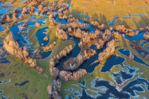
The vastness of Alaska offers an incredible range of scenery, each as appealing as the next. The state is a mosaic of contrasting ecosystems, ranging from the towering peaks of the Alaska Range to the sprawling tundra of the Arctic Coastal Plain. Denali, North America’s highest peak, towers over the state’s centre, while the Aleutian Islands extend southwestward, tracing a volcanic archipelago. Alaska also has glaciers, ice fields, deep forests, and pure rivers to explore, providing a spectacular array of natural splendour.
- Alaska is home to more than 100,000 glaciers, including the Mendenhall Glacier near Juneau and the Columbia Glacier near Valdez.
- Alaska has vast expanses of forests, including the Tongass National Forest, the largest national forest in the United States, and the Chugach National Forest, which surrounds the city of Anchorage.
- Large areas of Alaska are covered by tundra, a treeless landscape characterized by low-growing vegetation, permafrost, and harsh weather conditions.
- Alaska’s long coastline is home to countless bays, fjords, and islands, providing habitat for a diverse range of marine life, including whales, seals, and sea birds.
- This mountain range spans over 600 miles across central Alaska and is home to some of the state’s highest peaks, including Denali, North America’s tallest mountain.
These different landscapes are breathtaking and play an important part in the economy of Alaska, providing natural resources for sectors such as fishing, forestry, and tourism. They also support a diverse range of plant and animal life, making Alaska truly unique and special.
How Big Is Alaska, Compared With Other Land Masses?

Alaska Compared to Australia
Alaska and Australia are two distinct regions in terms of geography, climate, size, and population.
Alaska is the largest state in the United States, covering an area of approximately 1.72 million square kilometres, Meanwhile, Australia is the world’s sixth-largest country, spanning about 7.69 million square kilometres.
Alaska, with its vast landscapes and wilderness, has a relatively small population. As of my knowledge cutoff in September 2021, the estimated population of Alaska was around 731,000 people. On the other hand, Australia, being the sixth most populous country globally, had a significantly larger population of approximately 25.7 million people
Alaska Compared to Japan
Alaska is the largest state in the United States, covering an area of approximately 1.72 million square kilometres, meanwhile, Japan is an island nation located in East Asia and has a total area of about 377,975 square kilometres.
Japan is the 11th most populous country in the world, with an estimated population of 125 million people.
In summary, while Alaska is significantly larger in size compared to Japan, Japan has a much larger population.


Alaska Compared to Iceland
Alaska, the largest state in the United States, has a land area of approximately 1,717,854 square kilometres. In contrast, Iceland, a Nordic island country in the North Atlantic Ocean, has a land area of around 103,000 square kilometres.
Alaska is significantly larger than Iceland in terms of land area.
Alaska Compared to Colombia
Colombia, a country located in South America, has a land area of around 1,141,748 square kilometres.
In terms of land area, Alaska is larger than Colombia. However, it’s important to note that Colombia has a significantly larger population and is more densely populated compared to Alaska.


Alaska Compared to Mainland United States
The contiguous United States, also known as the “Lower 48,” has a combined land area of about 7,663,941 square kilometres.
This means that Alaska is roughly about one-fifth the size of the entire mainland United States. Learn About How Big Is Texas?
Alaska Compared to Europe
When comparing Alaska to Europe, there are significant differences in size. Alaska is the largest state in the United States, with a land area of approximately 1,717,854 square kilometres. In contrast, Europe is a continent comprising multiple countries and covers an area of about 10,180,000 square kilometres.
Alaska’s size is substantial, but it is still much smaller than the entire continent of Europe. Europe consists of 44 countries, including Russia, spanning Europe and Asia. So, while Alaska is geographically significant within the United States, it is dwarfed by the vastness of the European continent.

FAQs On The Size of Alaska
Frequently Asked Questions (FAQs) about the size of Alaska:
How many acres is Alaska?
Alaska is roughly 424.7 million acres in size.
What country in Europe is the size of Alaska?
The is no country in Europe that is roughly the size of Alaska, however, Ukraine is the largest country entirely within Europe and has a land area of approximately 603,500 square kilometres. Alaska, on the other hand, has a land area of about 1,717,854 square kilometres. While Ukraine is the closest in size to Alaska among European countries, it is still significantly smaller. It would take around 2.8x the size of Ukraine to come close to the size of Alaska.
How does Alaska compare to Russia in terms of size?
While Alaska is the largest state in the United States, it is much smaller than the Russian Federation. Russia’s land area, including both its European and Asian portions, is more than four times the size of Alaska.
What is the coastline length of Alaska?
Alaska has a vast coastline stretching for approximately 6,640 miles (10,686 kilometres). This extended coastline is due to Alaska’s numerous islands, fjords, and intricate shoreline.
How long does it take to drive across Alaska?
Driving across Alaska can vary greatly depending on the specific route, road conditions, and stops along the way. The state is vast and offers diverse landscapes, including mountains, forests, and vast stretches of wilderness.
If we consider the primary highway in Alaska, the Alaska Highway (also known as the Alcan Highway), which connects Alaska to the contiguous United States, the driving distance from Delta Junction, Alaska, to the Alaska-Canada border is approximately 370 miles. From there, the highway continues into Canada and connects to the rest of the North American road network.
Driving from Delta Junction to the northernmost city in Alaska, Utqiaġvik (formerly known as Barrow), is a significantly longer journey. It would involve travelling over 1,200 miles on the Dalton Highway, a mostly gravel road that passes through remote and rugged terrain.
Considering the varying conditions and factors, it’s difficult to provide an exact time for driving across Alaska.
How many states can fit in Alaska?
Alaska is the largest state in the United States and has a land area of approximately 1,717,854 square kilometres. To determine how many smaller states could fit within Alaska’s boundaries, we can compare their land areas.
For example, if we consider the smallest state in the United States, Rhode Island, with a land area of approximately 4,001 square kilometres, we can calculate that approximately 429 Rhode Islands could fit within Alaska.