Key takeaways
- Land Mass difference
- Coastal Difference
- Geography Of Canada
- Geography Of the United States of America
- Country difference stats
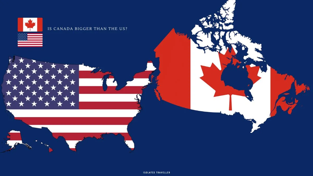
Is Canada bigger than the US?
Canada is the world’s second-largest country by land area, with the United States coming in third. According to the United Nations, as of 2021, the land area of the United States is approximately 9.8 million square kilometres, while the land area of Canada is approximately 9.9 million square kilometres. So, the United States is very close in size to Canada, and Canada is slightly larger in land area.
Land Mass difference
The United States has a land area of approximately 9.8 million square kilometres, while Canada has a land area of approximately 9.9 million square kilometres. This means that Canada is slightly larger than the United States in terms of land area, but the difference is not significant. Both countries are very large in size and among the largest in the world. However, it is worth noting that the population of the United States is much larger than that of Canada, with over 332 million people in the US compared to about 38 million people in Canada as of 2021.
Coastal Difference
The coasts of the United States and Canada have some notable differences.
The United States West Coast, which stretches from Washington to California, is known for its rugged coastline, steep cliffs, and rocky beaches. The climate in this region is mild and Mediterranean, with cool, wet winters and warm, dry summers. San Francisco and Los Angeles are two of the most beautiful cities along the coast. The East Coast of the United States, on the other hand, which runs from Maine to Florida, is known for its sandy beaches, barrier islands, and marshy wetlands. The climate in this region is humid subtropical, with hot, humid summers and cool to cold winters. The East Coast is home to some of the world’s largest and most densely populated cities.
The Canadian coastline is also diverse, encompassing a variety of ecosystems and climate zones. The West Coast of Canada, which includes the province of British Columbia, has a rugged coastline and a temperate rainforest climate, similar to the West Coast of the United States. The East Coast of Canada, which includes Newfoundland and Nova Scotia, has a more rocky and irregular coastline, as well as a subarctic climate with cold, snowy winters and cool summers.
Geography Of Canada

Canada is a country located in North America and is the second-largest country in the world in terms of land area. It shares borders with the United States to the south and to the northwest is Alaska (which is a US state). To the east is the Atlantic Ocean, and to the west is the Pacific Ocean. Canada also has a northern coastline along the Arctic Ocean.
Canada has a diverse geography, with various regions that have unique landscapes and features. The country is divided into ten provinces and three territories, each with its own distinct geography.
The Canadian Shield, which covers about half of Canada, is a rocky and hilly region that is rich in minerals and resources. The region is also home to many lakes and rivers, including the Great Lakes, which are some of the largest freshwater lakes in the world.
The Appalachian Mountains run through eastern Canada, while the Rocky Mountains extend through the western part of the country. The Prairies, located in central Canada, are vast flatlands that are ideal for agriculture.
Canada also has a significant number of forests, with the boreal forest, which stretches across much of the country, being the largest. The country is also home to many wildlife species, including polar bears, grizzly bears, wolves, moose, elk, caribou, and many others.
Overall, Canada’s geography is diverse and offers many opportunities for outdoor recreation and exploration.
Geography Of the United States of America

The United States of America is the third largest country in the world in terms of both land area and population. It is bounded to the north by Canada and to the south by Mexico, with the Atlantic Ocean to the east and the Pacific Ocean to the west. The United States is divided into 50 states, each with its own distinct geography, climate, and culture.
The geography of the United States is incredibly diverse, with mountains, plains, forests, deserts, and coasts covering a wide range of terrain. The Rocky Mountains, Appalachian Mountains, and Sierra Nevada are the most prominent mountain ranges in the United States. The Great Plains cover a large portion of the central United States, while coastal plains and wetlands dot the eastern seaboard.
The United States also has a number of major rivers, including the Mississippi River, the world’s fourth longest, and the Colorado River, which flows through the Grand Canyon. The country also has a number of large lakes, including the Great Lakes, which are the world’s largest group of freshwater lakes.
The United States has a wide range of temperatures and precipitation levels, with regions ranging from arctic tundra in Alaska to tropical rainforests in Hawaii. The country’s most populated areas, such as the eastern seaboard, the Great Lakes region, and the West Coast, generally have mild to moderate temperatures, whereas the interior and southern regions can have more extreme heat and cold.
Country difference stats
| Country | Canada | United States |
|---|---|---|
| Currency | Canadian Dollar ($) (CAD) | United States Dollar ($) (USD) |
| Government | Parliamentary democracy (federal constitutional monarchy) | The federal presidential constitutional republic |
| Time zone | (UTC-3.5 to -8) | (UTC−5 to −10) |
| Population | 38,142,273 (38th) | 329.5 million (2020 census) |
| Demonym | Canadian | American |
| Monarch | Queen Elizabeth II | None |
| Capital | Ottawa, Ontario | Washington, D.C. |
| National Anthem | God Save the Queen (Royal Anthem), O Canada (National Anthem) | Star-Spangled Banner |
| Date formats | DD/MM/YY | MM/DD/YYYY |
| Flag Colors | Red and white | Red, blue and white |
| National language | English, French (Official) | English |