Sheadings of the Isle of Man
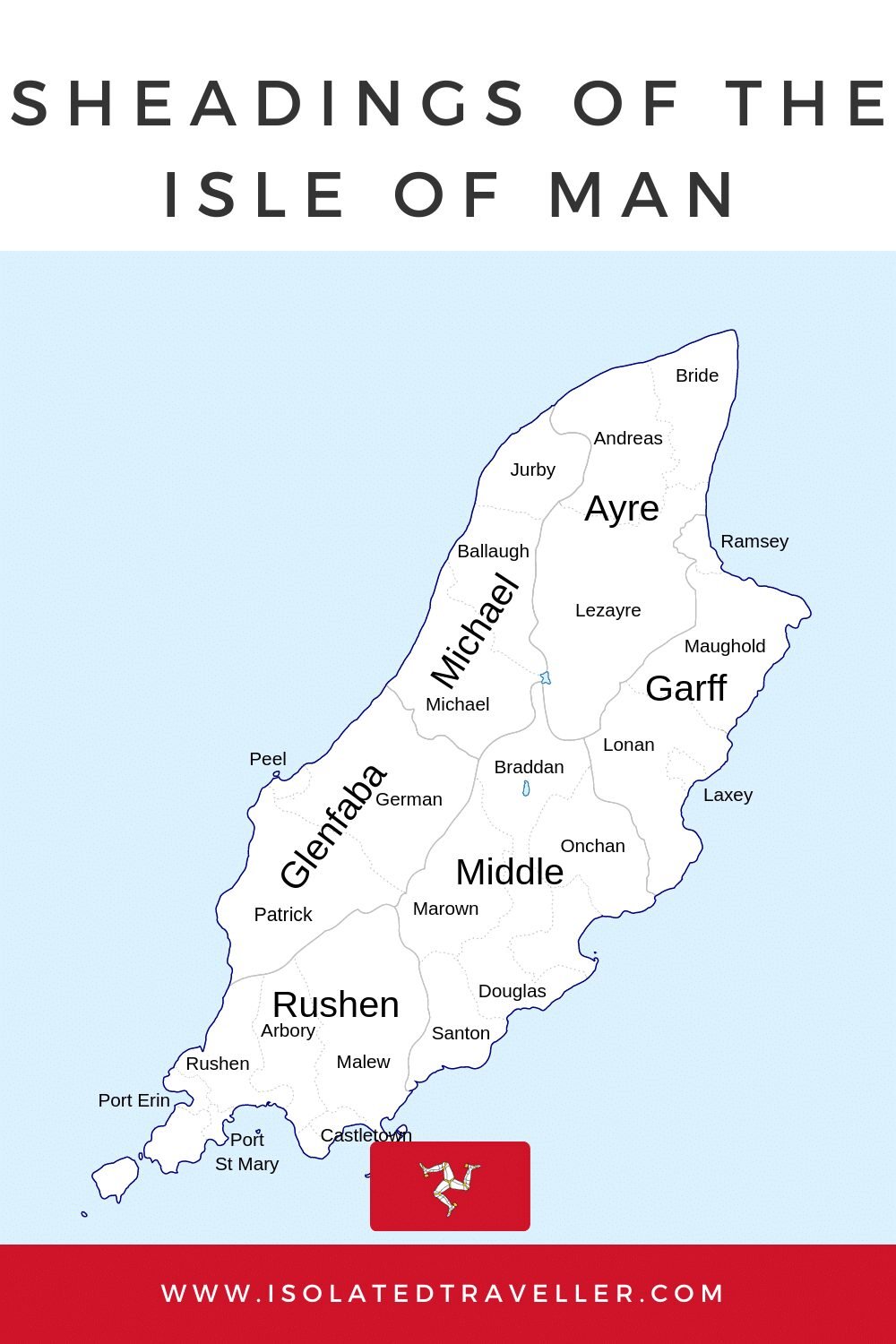
In the Irish Sea, there is a self-sufficient British Crown dependency called the Isle of Man. It is split into six historical “sheadings,” which are as follows:
- Ramsey is in the region of Ayre, which is in the north of the island.
- Peel is part of the Glenfaba neighbourhood on the west of the island.
- The towns of Laxey and Lonan are part of the Garff region, which is on the east of the island.
- Kirk Michael is part of the Michael region, which is in the southwest of the island.
- Braddan, Marown, and Santon are among the towns that make up the Middle region of the island.
- Rushen, in the southern part of the island, is home to the settlements of Castletown and Port Erin.
What is a Sheading?
Sheadings also spelt “Skeadings” are a historical term used in the Isle of Man to refer to traditional administrative divisions of the island. Originally, there were four Sheadings on the Isle of Man, each with its own local government and elected officials:
- Ayre – located in the northern part of the island
- Glenfaba – located in the western part of the island
- Michael – located in the southern part of the island
- Garff – located in the northeastern part of the island
Today, the Sheading system is largely symbolic and the local governments of the Sheadings have limited powers. The Isle of Man is now divided into six administrative regions called “constituencies,” which are further subdivided into smaller “wards.”
Learn more about the Isle of Man
List of Isle of Man Sheadings

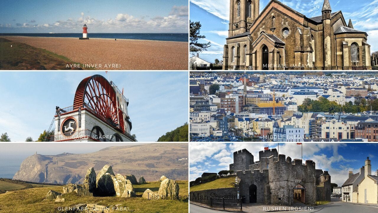
Ayre (Inver Ayre)
One of the Isle of Man’s six historical divisions, or “sheadings,” is Ayre. The town of Ramsey, the second-largest on the island after Douglas, is a part of it and is situated in the northern region of the island.
With its rolling hills, farms, and tiny villages, The Ayres Heading is primarily a rural area. The sandy stretches at Maughold and Laxey are just two of the well-liked beaches that line the sheading’s coastline.
The largest town in the Ayre sheading, Ramsey, is a thriving community with a population of close to 7,000. It is a well-liked vacation spot for both tourists and locals because of its historic harbor, Victorian-era buildings, and active events calendar. A number of significant cultural institutions, such as the Manx Museum, which examines the history and heritage of the Isle of Man, are also located in Ramsey.
The hills and moors of the northern interior, as well as the picturesque coastline, are among the natural wonders of the Ayre sheading. There are many walking trails and hiking routes that crisscross the area, making it a popular destination for hikers and outdoor enthusiasts. A lighthouse, an ancient burial site, and breathtaking views of the Irish Sea can all be found at the nearby Maughold Head.
Garff (Garff)
One of the Isle of Man’s six historical divisions, or “sheadings,” is Garff. It is situated in the eastern region of the island and has several smaller villages and hamlets in addition to the towns of Laxey and Lonan.
With its rolling hills, farms, and forests, Garff is primarily a rural area. The sheading’s coastline is rocky and rough, with a few tiny bays and coves. There are many hikers, cyclists, and outdoor enthusiasts who frequent the area because of its stunning natural surroundings.
Laxey, the largest town in Garff, has a population of about 1,700. The Lady Isabella waterwheel, which was built in 1854 in Laxey to pump water from the nearby mines, is renowned for its historic significance.
The town also has a scenic beach, several historic buildings, and a popular steam railway that runs from Douglas to Port Erin.
South of Laxey in Garff is a smaller village called Lonan. It has a population of about 1,000 and is well-known for its ancient church, which was built in the 12th century. Along with a number of small shops and cafes, the village also has a number of walking and cycling paths.
There are numerous historical sites and cultural organizations located in the Garff sheading. These include the Lonan Old Church, the Great Laxey Wheel, and the Manx Electric Railway, which travels through the sheading on its way from Douglas to Ramsey. The region is renowned for its traditional farming methods, which include raising the well-known Manx Loaghtan sheep.
Glenfaba (Glion Faba)
One of the six historical areas, or “sheadings,” of the Isle of Man is Glenfaba. It is situated in the western region of the island and has several smaller villages and hamlets in addition to the town of Peel.
With its rolling hills, farms, and forests, Glenfaba is mainly a rural area. The sheading’s rocky and untamed coastline has a number of tiny bays and coves. There are many hikers, cyclists, and outdoor enthusiasts who frequent the area because of its stunning natural surroundings.
Peel, the biggest settlement in Glenfaba, has a population of about 3,000. Peel is a historic port city with a marina, castle, and museum. The town is renowned for other things as well, including its stunning beach, busy calendar of events, and thriving arts and culture scene.
Glenfaba is also home to a number of important cultural institutions and landmarks. These include Tynwald Hill, the traditional site of the Isle of Man’s annual parliamentary ceremony, St. German’s Cathedral, and the Calf of Man bird sanctuary. The sheading is also known for its traditional farming practices, such as the raising of the famous Manx Loaghtan sheep.
Glenfaba is a beautiful and historic region of the Isle of Man, with a rich cultural heritage and a stunning natural landscape. There’s plenty to see and do in this beautiful part of the island, whether you’re interested in history, culture, or the great outdoors.
Michael (Maayl)
One of the six historical areas, or “sheadings,” of the Isle of Man is Michael (Maayl). It is situated in the southwest of the island and has Kirk Michael as well as several other smaller towns and villages.
With its rolling hills, farms, and forests, Michael is primarily a rural area. The sheading’s coastline is rocky and rough, with a few tiny bays and coves. There are many hikers, cyclists, and outdoor enthusiasts who frequent the area because of its stunning natural surroundings.
Kirk Michael, the town with the most residents in Michael, has a population of about 500. A church from the 12th century, along with a number of quaint stores and cafes, can be found in the historic village of Kirk Michael. Many walking and hiking routes pass through the nearby hills and forests, making the village a well-liked starting point for hikers.
Other significant landmarks and cultural institutions can be found in Michael. Among them are the 12th-century Rushen Abbey, a ruined abbey, the Tynwald Hill, and the medieval castle of Peel. The sheading is renowned for its customary farming methods, which include raising the renowned Manx Loaghtan sheep.
Overall, Michael is a beautiful and historic region of the Isle of Man, with a rich cultural heritage and a stunning natural landscape. There is a lot to see and do in this stunning area of the island, regardless of your interests in history, culture, or the great outdoors.
Middle (Medall)
One of the six historical divisions, or “sheadings,” of the Isle of Man is Middle (Medall). In addition to the town of St. John’s and a number of other smaller villages and hamlets, it is situated in the island’s center.
With its rolling hills, farms, and forests, Middle is primarily a rural area. The sheading’s coastline is largely flat and has a number of sizable estuaries and tidal bays. There are many hikers, cyclists, and outdoor enthusiasts who frequent the area because of its stunning natural surroundings.
St. John’s, the largest town in Middle, has a population of about 1,000. The 18th-century church in the historic village of St. John’s is home to a number of quaint stores and cafes. The Tynwald Hill, where the annual parliamentary ceremony for the Isle of Man is customarily held, is also located in the village.
Other significant cultural landmarks and institutions can be found in Middle. These include the Curraghs Wildlife Park, a well-liked tourist destination with a variety of exotic animals, and the picturesque beach and fishing community of Niarbyl Bay. The sheading is renowned for its customary farming methods, which include raising the renowned Manx Loaghtan sheep.
Overall, the Middle region of the Isle of Man is a lovely and historic area with a rich cultural heritage and a beautiful natural landscape. There is a lot to see and do in this stunning area of the island, regardless of your interests in history, culture, or the great outdoors.
Rushen (Rosien)
One of the six historical divisions, or “sheadings,” of the Isle of Man is Rushen (Rosien). It is situated in the southern region of the island and has several smaller villages and hamlets in addition to the town of Castletown.
The majority of Rushen is on the coast, and it is distinguished by rocky cliffs, sandy beaches, and rolling hills. The Chasms’ dizzying cliffs and the Calf of Man island are just two of the region’s notable landmarks. The coastline of the Sheading is particularly dramatic.
Rushen’s largest town, Castletown, has a population of about 3,000. A castle from the 13th century and other historic structures and landmarks can be found in the historic town of Castletown. The town is also home to the Old House of Keys, which was the original home of the Isle of Man’s parliament.
Other significant cultural landmarks and institutions can be found in Rushen. These include the Silverdale Glen, a picturesque wooded glen with a number of hiking trails and outdoor activities, the Isle of Man Railway Museum, and the Rushen Abbey, a ruined abbey from the 12th century.
Overall, Rushen is a stunning natural landscape and a beautiful and historic region of the Isle of Man. There is plenty to see and do in this beautiful part of the island, whether you’re interested in history, culture, or the great outdoors.
Interesting Facts About the Isle of Man


